You Won’t Believe What Lies Beneath Brasília’s Concrete Skyline
Brasília isn’t just a city of sharp angles and bold architecture—its terrain tells a wilder story. Nestled in Brazil’s high plains, the Cerrado biome shapes everything from the drainage patterns to the way sunlight hits the government buildings at dawn. I didn’t expect to be amazed by rock formations and ancient geological folds, but there it is. This is a landscape engineered by nature long before Niemeyer’s blueprints. If you think Brasília is all politics and planning, think again—something raw and ancient pulses beneath.
The Unexpected Face of Brasília
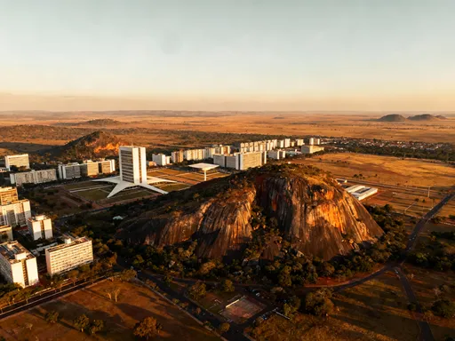
Most travelers picture Brasília as a grid of modernist monuments and broad avenues, a capital built from ambition and concrete. Yet beneath this carefully planned surface lies a far older narrative—one written in stone, shaped by time, and etched by forces that predate human memory. Sitting atop the Planalto Central, or Central Plateau, Brasília rests at an elevation exceeding 1,100 meters above sea level. This high-altitude positioning is not incidental; it is central to the city’s climate, air quality, and even the rhythm of daily life. The plateau itself is a remnant of ancient geological upheaval, where tectonic shifts over hundreds of millions of years pushed crystalline bedrock toward the surface, forming a rugged foundation that would later support one of the most ambitious urban projects of the 20th century.
Unlike coastal Brazilian cities such as Rio de Janeiro or Salvador, which were shaped by marine erosion and tropical weathering, Brasília’s topography emerged from inland processes—slow uplifts, deep erosion, and the gradual wearing down of ancient mountain chains. The terrain is characterized by gently rolling hills, flat-topped ridges, and subtle depressions that guide water flow across the landscape. These natural contours influenced where buildings could stand, how roads would curve, and where green spaces would thrive. While visitors often focus on the striking symmetry of the city’s airplane-shaped layout, few realize that this design was not imposed blindly onto the land but carefully adapted to its existing form. Engineers and planners relied heavily on topographic maps to ensure that construction respected the natural drainage and minimized environmental disruption.
The city’s elevation also contributes to a more temperate climate than much of tropical Brazil. With cooler nights, lower humidity, and frequent breezes, Brasília offers a respite from the sticky heat common in lower regions. This climate, in turn, supports a unique ecosystem—the Cerrado—Brazil’s vast tropical savanna and one of the most biodiverse grasslands on Earth. Far from being a barren backdrop to urban development, the Cerrado is a living, breathing system intricately tied to the underlying geology. Understanding Brasília means recognizing that its identity is not solely political or architectural, but deeply rooted in the land itself—a foundation of ancient rock and resilient vegetation that continues to shape the city in quiet, powerful ways.
Walking on Ancient Rock: The Geological Heart of the Cerrado
Beneath the paved plazas and manicured lawns of Brasília lies one of the oldest surfaces on the planet—the Brazilian Shield, a vast expanse of Precambrian rock that forms the ancient core of South America. Some of the exposed formations around the city are more than 500 million years old, predating complex life on land and surviving multiple cycles of mountain building and erosion. In parks like Parque da Cidade and along the shores of Lake Paranoá, visitors can see these ancient rocks emerge through the soil: twisted bands of quartzite, weathered granite domes, and iron-rich outcrops that glow red under the afternoon sun. These are not mere curiosities; they are the skeletal framework of the region, shaping everything from soil chemistry to plant survival strategies.
The Cerrado biome, which covers much of central Brazil and surrounds Brasília, thrives precisely because of these ancient, nutrient-poor substrates. Over millennia, plants have evolved specialized root systems, thick bark, and deep taproots to access water and resist fire—a natural cycle long maintained by seasonal dry spells and lightning strikes. The rocky terrain limits deep soil development, leading to a landscape dominated by hardy shrubs, twisted trees, and grasses adapted to drought and periodic burning. This adaptation is not weakness but resilience, a testament to life’s ability to flourish under constraint. The presence of these rock formations also influences groundwater movement, with fractures in the bedrock acting as conduits for subsurface flow, feeding springs and maintaining base levels in local streams.
For the observant traveler, these geological features offer more than scientific interest—they provide a sense of continuity and depth often missing in modern cities. Walking a trail through a preserved Cerrado reserve, one can place a hand on a sun-warmed boulder and feel a direct connection to epochs long past. Educational signage in protected areas explains how these rocks formed during the Neoproterozoic era, when tectonic collisions welded together fragments of early continents. There is a quiet dignity in this landscape, a reminder that human time is brief against the scale of geological change. Recognizing Brasília as part of this ancient system invites a deeper appreciation—not just of the city’s design, but of the enduring natural forces that made its existence possible.
How Terrain Shaped Urban Planning
When Lúcio Costa won the competition to design Brasília in 1957, he faced a challenge unlike any other: creating a capital city from scratch on a remote, undeveloped plateau. His famous pilot-shaped plan—comprising the Monumental Axis, Residential Wings, and extensive green zones—was revolutionary in form, but it was not conceived in isolation from the land. On the contrary, Costa and his team conducted detailed topographic surveys to understand the subtle rises, slopes, and natural watersheds of the site. The resulting design was not an imposition on the landscape, but a negotiation with it, one that respected the plateau’s contours to reduce construction costs, manage stormwater, and preserve ecological balance.
The Monumental Axis, which houses key government buildings including the National Congress and the Presidential Palace, was deliberately placed along a natural ridge. This elevated position not only provides symbolic prominence but also practical advantages: improved drainage, reduced flood risk, and unobstructed views across the city. By aligning major roads and structures with existing high ground, engineers minimized the need for extensive grading and earthmoving, preserving more of the native terrain. Similarly, the residential superblocks of the Asa Sul and Asa Norte were situated on slightly lower but still stable plateaus, where the ground could support dense housing without compromising structural integrity.
Green spaces were not afterthoughts but integral components of the city’s hydrological strategy. Costa’s plan included wide buffer zones between sectors, many of which follow natural depressions where rainwater naturally collects. These areas were preserved as parks or left as open fields, allowing water to infiltrate slowly into the ground rather than running off into overwhelmed drainage systems. Even the placement of Lake Paranoá, an artificial reservoir created during construction, was informed by the basin’s natural topography. Dams were built at strategic low points to capture runoff from surrounding hills, forming a body of water that now serves recreational, aesthetic, and environmental functions.
This integration of urban design with natural terrain was groundbreaking for its time and remains a model of thoughtful planning. While later expansions of the city have not always maintained this sensitivity, the original core of Brasília demonstrates how modernism and environmental awareness can coexist. For residents and visitors alike, understanding this relationship enhances appreciation for the city’s layout—not as a rigid imposition of order, but as a dialogue between human vision and geological reality.
Hidden Landforms Beyond the City Center
Just beyond the formal boundaries of Brasília’s urban grid, the land begins to reveal its wilder character. Within a short drive from the polished plazas of the capital, the terrain shifts into dramatic escarpments, forested valleys, and cascading waterfalls—features that reflect the dynamic geology of the Central Plateau. In areas like Sobradinho and Águas Claras, rolling hills break the monotony of the urban sprawl, their slopes covered in native Cerrado vegetation. These landscapes are not only scenic but ecologically significant, serving as corridors for wildlife and reservoirs of biodiversity increasingly threatened by unregulated development.
One of the most accessible natural wonders near Brasília is Salto de Santo Antônio, a seasonal waterfall located just outside the Federal District. During the rainy months, water rushes over ancient sandstone cliffs, carving deep pools below and creating a cool microclimate favored by birds, amphibians, and local families seeking relief from the heat. The rock face displays clear sedimentary layers, evidence of deposition in a long-vanished inland sea. Nearby trails allow visitors to explore the surrounding vegetation, where bromeliads cling to rocks and armadillos scurry through the underbrush. Though modest in size compared to Brazil’s grander falls, Salto de Santo Antônio offers an intimate encounter with the region’s geological and ecological heritage.
For those willing to travel further, Chapada dos Veadeiros National Park—located about 200 kilometers north in the state of Goiás—offers a breathtaking showcase of the Cerrado’s full splendor. Designated a UNESCO World Heritage Site for its ecological and geological significance, the park features table-top mountains, deep canyons, and crystal-clear rivers that cut through quartzite formations older than the Amazon rainforest. Trails lead to panoramic viewpoints, hidden waterfalls like Cachoeira do Segredo, and natural swimming holes surrounded by rock walls streaked with iron oxide. The park’s elevation, which exceeds 1,500 meters in places, contributes to cooler temperatures and frequent mist, creating an atmosphere both serene and majestic.
These destinations remind us that Brasília is not an isolated urban island but part of a larger, living landscape. They offer opportunities for hiking, birdwatching, and quiet reflection, drawing visitors into a deeper relationship with the natural world. Local tour operators provide guided excursions that emphasize environmental education and low-impact practices, ensuring that exploration does not come at the expense of conservation. Whether through a weekend hike or a guided geology tour, engaging with these landforms allows travelers to see Brasília not just as a political center, but as a gateway to one of Brazil’s most underrated natural regions.
The Role of Water in a High-Altitude Basin
Water behaves differently in Brasília than in most Brazilian cities, and the reason lies in its unique hydrology. The Federal District sits within a closed drainage basin, meaning that rainwater does not flow out to the sea but instead collects internally, primarily feeding Lake Paranoá and recharging underground aquifers. This closed system makes water management especially critical, as pollution or overuse can have long-term consequences. The relatively flat topography slows runoff, allowing water to percolate through porous soils and fractured bedrock. However, urban expansion has altered this natural process, increasing impervious surfaces and accelerating surface flow, which raises the risk of erosion and flash flooding in vulnerable areas.
Among the most important natural features in this system are the veredas—seasonal wetlands dominated by buriti palms and spongy, organic-rich soils. These palm-filled marshes act like natural sponges, absorbing rainfall during the wet season and releasing it slowly during the dry months. They are vital for maintaining base flow in streams and replenishing groundwater supplies. Ecologically, veredas are hotspots of biodiversity, providing habitat for species such as the maned wolf, the giant anteater, and numerous migratory birds. Despite their importance, these fragile ecosystems are under threat from land clearing, illegal wells, and urban encroachment.
Lake Paranoá, the city’s largest artificial reservoir, plays a central role in both water storage and recreation. Created in the late 1950s by damming local streams, the lake covers over 40 square kilometers and serves as a visual centerpiece for the city. It also supports boating, fishing, and waterfront parks, contributing to residents’ quality of life. However, maintaining water quality has been an ongoing challenge due to nutrient runoff from surrounding developments. In response, environmental agencies have implemented monitoring programs, restored riparian buffers, and promoted public awareness campaigns to reduce pollution.
Understanding Brasília’s water cycle underscores the importance of sustainable land use. Every paved surface, every cleared patch of native vegetation, affects how water moves through the landscape. Conservation efforts now focus on protecting remaining veredas, restoring degraded areas, and integrating green infrastructure—such as permeable pavements and rain gardens—into new developments. For visitors, this means that respecting natural zones, staying on marked trails, and avoiding littering are small actions with real impact. Water, in this high-altitude basin, is not infinite—it is a shared resource shaped by geology, climate, and human choices.
Why This Terrain Matters for Sustainable Travel
Travelers often overlook plateau cities in favor of coastal resorts or mountain retreats, but Brasília’s elevated terrain offers distinct advantages for sustainable tourism. Its altitude brings milder temperatures, clearer skies, and lower humidity, reducing the need for air conditioning and enhancing outdoor comfort. The open landscape allows for abundant natural light, supporting solar energy initiatives and energy-efficient building design. Moreover, the city’s original master plan included extensive green belts and low-density zones, creating opportunities for urban agriculture, community gardens, and native plant restoration—all of which contribute to ecological resilience.
Yet development pressures threaten these benefits. Soil compaction from construction, loss of native Cerrado cover, and increased runoff degrade the land’s ability to support life. The Cerrado, though less famous than the Amazon, is equally vital as a carbon sink and water regulator. Already, nearly half of its original extent has been converted to agriculture or urban use. In the Brasília region, protecting remaining fragments is essential not only for biodiversity but for maintaining the city’s long-term livability.
Sustainable travel in Brasília means engaging with the landscape mindfully. Guided geological walks, eco-tours of protected areas, and visits to environmental education centers help visitors understand the region’s natural history while supporting local conservation efforts. Choosing accommodations that prioritize energy efficiency and water conservation, eating at restaurants that source local ingredients, and using public transportation or bicycles reduce environmental impact. Supporting NGOs that work to restore native vegetation or protect veredas allows tourists to contribute directly to preservation.
Even small actions—such as staying on trails, avoiding plastic waste, and learning about the Cerrado’s unique plants—can foster a deeper connection to place. Sustainable travel is not about perfection but awareness: recognizing that every choice affects the environment and that respect for nature enhances the travel experience. In Brasília, where the land speaks through rock and savanna, this awareness transforms a simple visit into a meaningful encounter with one of Earth’s oldest and most resilient ecosystems.
Reimagining Brasília: From Concrete to Natural Wonder
Brasília’s reputation as a triumph of modernist architecture often overshadows its deeper identity—as a city built upon ancient, enduring land. While its clean lines and monumental scale continue to draw admiration, a growing number of residents and visitors are learning to see beyond the concrete. They are discovering that the true marvel of Brasília lies not only in what was constructed but in what was already there: a landscape shaped by eons of geological change, home to a unique and fragile biome, and alive with quiet beauty.
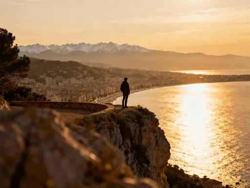
Standing on a rocky outcrop at sunset, watching golden light spread across the endless savanna, one feels a shift in perception. The city no longer seems separate from nature but part of a continuous dialogue between human creation and natural foundation. The same forces that lifted the Brazilian Shield also guided the path of roads, the placement of parks, and the flow of water through the urban fabric. Recognizing this connection fosters a sense of humility and responsibility—a reminder that even the most carefully planned cities depend on the stability and health of the land beneath them.
This reimagining invites travelers to look deeper, to move beyond guided tours of government buildings and seek out the natural wonders that surround the capital. It encourages slow travel, thoughtful observation, and respect for the Cerrado’s delicate balance. By supporting conservation, choosing eco-friendly practices, and sharing stories of the region’s hidden landscapes, visitors become stewards of a place that deserves greater recognition.
Brasília is more than a political symbol or architectural experiment. It is a living city grounded in ancient rock, shaped by wind and water, and sustained by a resilient ecosystem. To understand it fully is to see the silent, enduring power of the Earth—not as a backdrop, but as a partner in the story of human settlement. In this light, Brasília emerges not as a city apart from nature, but as a testament to the possibility of harmony between design and the deep time of the natural world.